
Exhibition: Colors of the Nation
Tapolca-Diszel, Hungary
August 24, 2011, 09:15 UTC (11:15 local time)

Loading panorama viewer ...
Configuring ...
© 2011 Zoltán Bánfalvy,
Some Rights Reserved.

Caption
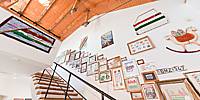
This is an Image Museum or Art Gallery located in Tapolca-Diszel village at the Balaton Uplands.
It was an abadoned watermill which was rebuilt during the '90s.
The reconstruction was made according to the plans of Péter Mújdricza, who also planned The Wooden Church of Magyarföld.
I took this panorama during the "Colors of the Nation" exhibition. The Red-White-Green are the national colors of Hungary, red for the blood spilled for the fatherland, white for freedom and green for the land, for the pastures of Hungary.
Látványtár official homepage
Ez a panoráma az "Egy + 1 : A rózsaszínről és a nemzet színeiről" c. kiállítás idején készült a Látványtárban, ami valójában két kiállítás volt térben és időben egy helyen.
Location
Lat: 46° 53' 15.07" N
Long: 17° 29' 48.88" E
Elevation: 120
Precision is: High. Pinpoints the exact spot.
Equipment
HW: Canon EOS 350D, Peleng 8mm f/3.5, home-made panoramic head, Garmin eTrex Vista HCx;
SW: PTGui & Smartblend, Pano2QVTR
Panography Assistant: É. R.T. :)
 Tap or click the zoom icon in the bottom right corner of the picture to switch between in-page and fullscreen view