

Loading panorama viewer ...
Configuring ...
© 2010 Willy Kaemena, All Rights Reserved.
Caption
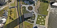
The Weser Tower is a 22-floor tall building in Bremen, designed by the US-American architect of German origin Helmut Jahn. The laying of the foundation was on 23 October, 2007, and it was completed in 2010. The Tower's height of 82 meters makes it the tallest office building in Bremen.
Location
Lat: 53° 4' 57.99" N
Long: 8° 47' 14.51" E
Elevation: 89
Precision is: Unknown / Undeclared.
Equipment
Nikon D300 with Sigma 8mm 3.5 Fisheye on two coupled monopods, handheld with remote trigger.PTGui, Photoshop, Photomatix4, CubicConverter
Behind the scene : how this panorama was made
The pictures for this panorama were taken from the roof of the building. This roof has a glass wall of about 4m height almost all around the roof edge.See a photo of the building here where you can see that glass wall on the roof.
I used two coupled monopods in order to get the camera slightly over the edge of that wall. A total of about 20 photos were taken, while walking along the roof wall. Stitching and post processing were a challenge as huge parallax errors were produced by taking the pictures on this large rectangle roof.
 Tap or click the zoom icon in the bottom right corner of the picture to switch between in-page and fullscreen view