

Loading panorama viewer ...
Configuring ...
© 2010 Rolf Ris, All Rights Reserved.
Caption
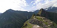
Machu Picchu—"Old Mountain"—is a pre-Columbian 15th Century Inca site located 2,430 metres (7,970 ft) above sea level. It is situated on a mountain ridge above the Urubamba Valley in Peru, which is 80 kilometres (50 mi) northwest of Cusco and through which the Urubamba River flows.Most archaeologists believe that Machu Picchu was built as an estate for the Inca emperor Pachacuti (1438–1472). Often referred to as "The Lost City of the Incas," it is perhaps the most familiar icon of the Inca World.
I decided to use this pano for the "Best-of-Event" because of my memories to get there. There are only two ways to go to Machu Picchu. The first is to take the train to Aguas Calientes and then the bus up to the mountain. The second is to use the Inca trail. The Inka trail can be done in a 4 or a 2-day trekking-trip. We chose the 2-day-trip and felt happy as we walked through the sun-gate and had our first view to this great site.
Location
Lat: 14° 10' 51.44" S
Long: 73° 33' 42.75" W
Elevation: 2430
Precision is: High. Pinpoints the exact spot.
Equipment
Nikon D300 - Nikkor 10.5mm (fullframe fisheye)
Monopod with Nodal Ninja 3
PTGui Mac - Photoshop
Macbook Pro - OSX 10.6
 Tap or click the zoom icon in the bottom right corner of the picture to switch between in-page and fullscreen view