
Funeral for a Forest
South March Highlands, Kanata, Ontario, Canada
August 24, 2010, 14:00 HRS

Loading panorama viewer ...
Configuring ...
© 2010 Robert Agnel, All Rights Reserved.
Caption
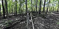
The South March Highlands are a unique feature of the west Ottawa community of Kanata. Located at the southern tip of the Precambrian Shield bedrock outcrop known as the Carp Hills the rocks in this area are over 1 billion years old. This rich old-growth forest is one of the last remaining within the city of Ottawa, Canada's capital.This beautiful 1,100 hectare forest is under threat from land developers and the four-lane road being built by the city through the heart of this unique ecosystem.
The previous and present City of Ottawa council and the two land developers are locked in their respective positions. They are unwilling to cooperate and settle this important land-use issue. The community has very little say in how their neighbourhood will be developed. The original design and development of Kanata respected natural rock outcrops, creeks and large trees. The streets and house position on the lots were placed to take advantage of nature and build a community around these unique features.
Today this 1,000-year-old forest will be clear-cut and the rocks blasted flat. A large area of significant wetlands will be threatened by the loss of this forest and 18 species-at-risk will lose more of their habitat. Future generations will miss out not having this unique forest in the center of community life. The trails are enjoyed year round by walkers, bicycles and skiers, young and old.
In 12,000 BCE the Ottawa Valley was at the bottom of the Champlain Sea and the South March Highlands was a significant island. There are indications that this area supported a thriving hunter-gatherer society. Recently small stone circles have been found in the forest and might indicate early Algonquin grave sites or special ceremonial locations.
On August 24, 2010, at 7:00 pm Algonquin Elder, poet and community activist Albert DuMont invited the community for a special Traditional Tobacco Offering Blessing and Prayer for the land. As the First Peoples to inhabit the Ottawa Valley the Algonquin have a special role as the traditional Stewards of these lands and protectors in the spirit of The Algonquin teaching of the "Inter-connectivity of All Our Relations."
This panorama was produced about 1,000 meters inside the eastern edge of the forest north of the Beaver Pond. Out of respect for Algonquin Tradition, no photography was done during the ceremony.
Location
Lat: 45° 20' 0" N
Long: 76° 56' 13" W
Elevation: 95 meters
Precision is: Medium. Nearby, but not to the last decimal.
Equipment
Nikon D90; Nikkor 10.5mm; Pano2VR; Stitcher Unlimited; Atome VR head;
 Tap or click the zoom icon in the bottom right corner of the picture to switch between in-page and fullscreen view