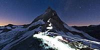

Climbers Start Their Ascent Up the Matterhorn
Zermatt, Switzerland
August 9, 2010, around 4:30 am

Loading panorama viewer ...
Configuring ...
© 2010 Matthias Taugwalder, All Rights Reserved.
Caption
This panorama was shot on August 9, 2010, around 4:30 am in the morning, at the foot of the Matterhorn. The Matterhorn is well-known for its unique and beautiful form, its importance in the history of alpinism and the dramatic story of its first ascent. The ascent over the classic Hörnli ridge takes two days from Zermatt; one to approach the Hörnli Hut, the second to climb the route and return to Zermatt. In the picture you can see the light trails of the headlamps of the 80 climbers that day starting their 4-5 hour ascent to the summit.
This is my contribution to the selection of "Best of 2010" panoramas because of several reasons:
First, because I had this image in my mind for several years now. Although I had figured out the technical details how to shoot and post-process it, shooting it was still a challenge due to the night exposure. It was a relieving moment standing there in the dark and cold, seeing the images appear on the camera's LCD display and realizing that I managed to capture the moment exactly as I had imagined it.
Second, because I shot this panorama at the same location, where I shot 7 years ago my first widely-known panorama, that was later published on Panoramas.dk.
Third, because this is one of the many panoramas that I shot during the last year on behalf of the Swiss newspaper Blick.
Fourth, and last, but not least, because I found out last week, that this image made it into the 50 finalists of the 2010 National Geographic Photo Contest - out of more than 16,000 photographs submitted.
2010 — one more truly panoramic year!
http://www.alps360.ch - Breath-taking panoramic images!
Equipment
Nikon D300, Nikkor 10.5mm fisheye, Seitz Roundshot VR Drive
 Tap or click the zoom icon in the bottom right corner of the picture to switch between in-page and fullscreen view