WWP Home arrow right This Event arrow right Indices: Alphabetical | Regional | Thumbnail | Map previousPrevious | Nextnext
event title
Europe
portrait Martin Hrdlička
Aerial Panorama above Třebíč
Trebic, Czech Republic
mini manual
[?]
Copyright © 2010 Martin Hrdlička, All Rights Reserved
VirtualPanorama.cz
Previous panorama: John HoughtonfullscreenA-Z Regions ThumbnlsShow in MapNext panorama: Marc W. Huff

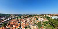
The aerial panorama above the centre of Czech Unesco Heritage in Trebic.

This is a starting picture of the Virtual Tour made for the town of Trebic, which you can find here.

Location Map Geographic Coordinates:
Latitude: 49° 13' 4" N
Longitude: 15° 52' 43" E
arrow Show at MultiMap.com [what is MultiMap?]
arrow Show at Google Maps [what is Google Maps?]
arrow Show in Google Earth* [what is Google Earth?]
* requires Google Earth
installed on your computer

Date/Time:
August 15, 2010, 13:40

Equipment:
Helicopter and courage.


http://www.virtualunesco.cz

http://www.virtualczech.cz

text
WWP Home arrow right This Event arrow right Indices: Alphabetical | Regional | Thumbnail | Map previousPrevious | Nextnext