

Loading panorama viewer ...
Configuring ...
© 2011 Luis Benitez, All Rights Reserved.
Caption
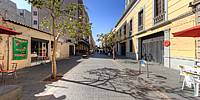
La calle Regina es una de las calles del Centro Histórico de la Ciudad de México que ha sido recuperada y remodelada por el gobierno de la Ciudad y se ha convertido en un espacio de circulación peatonal apacible que se extiende aproximadamente 500 mts. entre las avenidas de 20 de Noviembre y Bolivar. Es una calle con bancas de descanso, edificios de la época colonial y de principios del siglo XX, muchos de éstos ahora convertidos en pequeños negocios, hostales y restaurantes que le dan un toque bohemio al lugar.
Regina is a street in the Historic Center of Mexico City that has been restored and renovated by the city government and has become a peaceful pedestrian circulation space that extends approximately 500 meters between Avenues 20 November and Bolivar. Regina street has benches for rest, colonial-era and early twentieth century buildings; many of these are now converted into small businesses or restaurants that give the place a bohemian touch.
Location
Lat: 19° 25' 39.34" N
Long: 100° 9' 4.42" W
Elevation: 2228 m
Precision is: High. Pinpoints the exact spot.
Equipment
Nikon D70 + Nikkor 10.5 mm, Nodal Ninja 5, 3021BPRO Manfrotto tripod, Photoshop, PTGui, CubicConverter.
 Tap or click the zoom icon in the bottom right corner of the picture to switch between in-page and fullscreen view