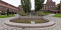

Kungliga Tekniska Högskolan – Royal Institute of Technology
Valhallavägen 79, Stockholm, Sweden
September 12, 2010, 08:12 UTC

Loading panorama viewer ...
Configuring ...
© 2010 Lennart Mollerstrom,
Some Rights Reserved.

Caption
"Kungliga Tekniska Högskolan" or "KTH" as it is usually called (in English "KTH Royal Institute of Technology") is a university campus in Stockholm Sweden. KTH is highly respected worldwide. The buildings here were completed in 1917. Architect Eric Lallerstedt.
Equipment
Hardware: Pentax K20D with Pentax 10-17mm fisheye @10mm, Nodal Ninja 3 MKII, Benro A-298 n6 tripod.Software: Lightroom 3.3, Hugin, Enblend/Enfuse, Photoshop CS5, Pano2VR.
 Tap or click the zoom icon in the bottom right corner of the picture to switch between in-page and fullscreen view