

© 2010 Jürgen Eidt, All Rights Reserved.
Meriwether Lewis and William Clark led the first United States expedition (1804–1806) to the Pacific Coast. Its goal was to establish U.S. sovereignty over the tribes along the Missouri River, open trade and claim the rights of discovery to the Pacific Northwest and Oregon territory before the British. The expedition also sought an accurate sense of the resources being exchanged in the Louisiana Purchase, collected scientific data, and hoped to find a Northwest Passage.
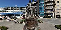
This panorama shows the sculpture of Lewis and Clark reaching the end of their journey in Seaside, Oregon.
More pictures from that day and details on how this panorama was created can be found here.
Nikon D700, Sigma 8mm f/3.5, PTgui Pro 9, Handheld 4+Z+N
 Tap or click the zoom icon in the bottom right corner of the picture to switch between in-page and fullscreen view