

Loading panorama viewer ...
Configuring ...
© 2010 Jozsef Urmos, All Rights Reserved.
Caption
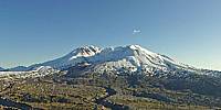
The steaming lava dome in the heart of Mount St. Helens crater in mid-winter from the entrance plaza of Johnston Ridge Observatory. The visitor center memorializes USGS volcanologist Dave Johnston who was at the nearby Coldwater II monitoring post nearly 30 years ago on the morning of 18 May, 1980, when Mt. St. Helens erupted catastrophically. The eruption, triggered by a 2.8-cubic-kilometer landslide that shaved over 400 meters off the formerly symmetrical peak, devastated nearly 625 square kilometers of forested landscape. Mt. St. Helens reawakened again in late 2004 and gradually built a series of lava domes and spines until ending in early 2008.
Now, two years since the most recent eruption stopped, only a few thin wisps of steam are visible above the new domes within the crater. The low winter sun highlights the raw, rugged landscape surrounding the peak. Johnston Ridge Observatory and the access road are closed during winter, and this viewpoint can only be reached by a long trail hike. The beginning of 2010 was rather dry and snow cover was unusually light in the Cascade Mountains. The day I shot this panorama was one of the last clear days of the winter; wet, snowy conditions soon returned and persisted well into late spring.
See the Mount St. Helens National Volcanic Monument and Cascades Volcano Observatory web sites for information about Mt. St. Helens.
Location
Lat: 46° 16' 33.02" N
Long: 123° 14' 0.68" W
Elevation: 4230 ft.
Precision is: High. Pinpoints the exact spot.
Equipment
PENTAX K10D, PENTAX DA 10-17mm at 10mm, Nodal Ninja 3, PTGui Pro.
 Tap or click the zoom icon in the bottom right corner of the picture to switch between in-page and fullscreen view