

Loading panorama viewer ...
Configuring ...
© 2010 Jim Watters,
Some Rights Reserved.

Caption
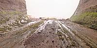
On Fathers Day 2010 I went with my wife and her father to the beach of Saint Martins to collect rocks. While there I explored Echo Cave. Echo Cave is a sea cave cared out of the sandstone by the rising and falling tides. The water flows into the cave every high tide. The entrance is over 30 feet high.Saint Martins is a part of Stonehammer Geopark, the first North American member of the UNESCO–supported Geoparks Global Network.
Visibility was limited outside because of the fog.
photocreations.ca
Location
USA-Canada / Canada-New Brunswick
Lat: 45° 21' 27.5" N
Long: 66° 32' 23.11" W
Elevation: 0
Precision is: Medium. Nearby, but not to the last decimal.
Equipment
Nikon D70s camera, with Nikkor 10.5mm fisheye lens, and
Nodal Ninja.
Enfused three exposures of each 6 around, 1 up, & 1 down
PTGui 9
 Tap or click the zoom icon in the bottom right corner of the picture to switch between in-page and fullscreen view