

Loading panorama viewer ...
Configuring ...
© 2010 Jesse Lee 李景超(鱼眼龙), All Rights Reserved.
Caption
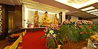
The Longquan Monastery is located at the foot of the Phoenix Range in the Western Mountains in Beijing. It was first built in 951, the first year of the Yingli reign of the Liao dynasty. In the courtyard, two one-thousand-year old gingko trees as well as two cypress trees of similar age have borne witness to the vicissitudes of the monastery. The Golden Dragon Bridge, a single-arch stone bridge that is still visible today was built with donations collected by the Venerable Master Jisheng, the first abbot of the monastery one thousand years ago. His stupa can be worshiped to the east of the monastery. It’s said that, on the day that Venerable Master Jisheng achieved nirvana, the sky filled with auspicious clouds and birds sang merrily in the woods. For forty-nine days, monks chanted around the stupa. The soothing fragrance of sandalwood emitted by the stupa lasted for three years.Buddhism used to flourish in the areas around the Phoenix Range. There are many caves for Buddhist retreats in the mountain including Three Buddhas Cave, Xuanyuan Cave, Immortal’s Chair Cave and Fairy Cave. Some of the engraved Buddhist sculptures are still clear and complete today.
After rises and falls, on April 11, 2005, the Longquan Monastery was officially reopened for Buddhist services. It became the first Buddhist monastery with Buddha, Dharma, and the Sangha, namely the Three Jewels, officially opened in Haidian district of Beijing since the establishment of the People’s Republic of China.
The Longquan Monastery offers Buddhist education and temple experience in both Chinese and English.
Equipment
Canon 400D, Sigma 8mm fisheye.
 Tap or click the zoom icon in the bottom right corner of the picture to switch between in-page and fullscreen view