
Wind Power Subject, Wind Power Camera
Kinderdijk World Heritage Site, The Netherlands
May 4, 2010, 13:50 UT (15:50 local time)

Loading panorama viewer ...
Configuring ...
© 2010 James Gentles, All Rights Reserved.
Caption
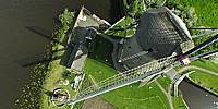
Built in 1740, the windmills at Kinderdijk demonstrate that being "green" isn't something new. This area is kept dry, despite being below sea level, in a truly carbon neutral way—the power of the wind!How appropriate that this image was taken by a camera lifted into the air by a kite.
The image was taken in May, 2010, at an international convention of Kite Aerial Photographers, which met in The Netherlands.
Location
Lat: 51° 52' 57.36" N
Long: 4° 38' 29.04" E
Elevation: -2m, 45m AGL
Precision is: High. Pinpoints the exact spot.
Equipment
Nikon 8400 with FC-E9 Lens. Homemade camera cradle/rig, triggered by a
gentLED
intervalometer. Suspended below a Rokkaku Kite with a 6ft/2m span.This technique produces two hemispheres, and a different workflow in PTGui from the classic ground pano technique. This results in lower resolution BUT impossible angles!
See the rig, how Kite Aerial Photography is achieved, and the workflow.
 Tap or click the zoom icon in the bottom right corner of the picture to switch between in-page and fullscreen view