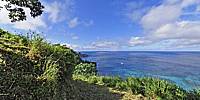

Chatham Bay
Chatham Bay, Coco's Island, Costa Rica
Septermber 29, 2010, 1:00 pm local time

Loading panorama viewer ...
Configuring ...
© 2011 Isaac Martinez,
Some Rights Reserved.

Caption
A brief view of a great place…by Marco Garrido
With almost 46.6 square kilometers, 24 kilometers of coastline and located two hundred and seventy miles Southeast of Costa Rica; Cocos Island represents a world-known nature’s jewel which the memorable Jacques Ives Cousteau(1910-1997), scientific oceanographer, professional diver and filming director of sealife documentaries, brought up this island worldwide through the communication media together with his Calypso Ship's crew, in the late '80s.
Cousteau deemed Cocos Island as ”the most beautiful island in the world…” and Michael Crichton wrote “Jurassic Park” with this place in mind. Cocos Island was inscribed as a World Heritage Site in 1997 by UNESCO and more recently it has been nominated as a candidate in the 2nd phase of the New 7 Wonders of the World contest.
Exuberant vegetation typical of tropical rainy climates and a high level of rainfall generates abundant rivers of fresh and crystalline waters that cascade into the sea in waterfalls of extraordinary beauty.
A rugged-shaped coastline full of steep cliffs, turns the island in an almost impregnable fortress which rises over 500 feet above sea level. The only points of access are two bays: Chatham Bay and Wafer Bay, which are separated from each other by the “Presidio” Peninsula. Mount Iglesias which reaches an altitude of 2,178 feet over the sea, is the island’s highest peak.
Since Cocos Island was first mentioned in 1541 in Nicolás Desliens cartographic map, it is assumed that it was discovered before that date. Nevertheless, its exact date of discovery is not known. In Desliens’ map it is identified as “Coques” (Inst. Geog. of C.R., pp. 33., 1964).
It is said that Cocos Island owes its name to the abundance of coconut palms and fruit. A captain by the name of Colnett mentioned having loaded 2,000 coconuts onto his ship on a visit to the island in 1793.
Location
Lat: 5° 32' 53.45" N
Long: 88° 3' 41.84" W
Elevation: 450 meters
Precision is: Medium. Nearby, but not to the last decimal.
Equipment
Nodal Ninja 3 MK II, R-D8 Rotator, Nikon D300 with Nikkor 10.5mm, PTGui Pro 8.3.10, Photoshop CS5, CubicConverter, Nikon Capture 4.
Mi cumple número 40 en la Isla del Coco (Spanish)
Tuve la gran oportunidad de viajar a la Isla del Coco para mi cumpleaños numero 40 en Setiembre del 2010. Fue una experiencia inolvidable el poder compartir con otros 20 buzos de diferentes nacionalidades durante 10 días a bordo del Okeanos Aggressor.La travesía a la Isla del Coco toma alrededor de 36 horas en barco y es una experiencia unica el poder pasar navegando dos noches completas sin visualizar absolutamente nada de tierra en el horizonte.
Una vez en la isla, el barco fondea en Chatham Bay, desde donde luego de dos dias de buceo, el grupo decidió realizar una visita a tierra y ascender hasta el mirador del Aguacate desde donde fue tomada esta fotografia de 360º.
La fauna marina es abundante y tambien es exhuberante la flora y vida silvestre en el bosque tropical lluvioso que predomina en la isla. Aqui llueve 7000 milimetros al año y abundan las cataratas por todos los puntos cardinales de la Isla.
Tambien hay diversos sitios de buceo que es la actividad principal de los turistas que visitan esta zona. Se pueden observar varias especies de tiburones, entre ellos el punta blanca, punta plateada, sedoso, galapagos, martillo y el impresionante tiburón ballena.
Tambien son abundantes diversos tipos de rayas y muchisimos peces de todos tamaños asi como langostas y pulpos. Es uno de los diez sitios mas populares en el mundo para el buceo recreativo y el lugar con mayor concentración en el mundo de tiburones martillo.
 Tap or click the zoom icon in the bottom right corner of the picture to switch between in-page and fullscreen view