
On the Haul Road North of the Arctic Circle
Near Alaska Pipeline Pump Station Four on the Dalton Highway, North Slope of the Brooks Range, Alaska, USA
September 3, 2010, 2:00 pm Alaska Time

Loading panorama viewer ...
Configuring ...
© 2011 G. Donald Bain, All Rights Reserved.
Caption
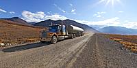
The Dalton Highway, also called the Haul Road, parallels the Alaska Pipeline from just north of Fairbanks to the oil fields at Prudhoe Bay. It is 415 miles (670 km) long, mostly unpaved, and 3/4 of it lies north of the Arctic Circle. Heavy truck traffic uses it all year, with a sprinkling of tourists in summer. Fuel and emergency assistance are available at only two places along the highway and the only "town" is Deadhorse at the north end.This panorama was taken in the Atigun Valley on the north side of the Brooks Range, 160 miles (260 km) north of the Arctic Circle. The mountains to the southwest are in Gates of the Arctic National Park, and the coastal plain to the northwest is in the Arctic National Wildlife Refuge.
The pipeline, elevated on posts to prevent melting the permafrost, can be seen in the bottom of the valley, and Pump Station Number Four is to the north. A heavy (26-wheel) truck roars by at 70 mph (110 kph) leaving a cloud of dust.
The vegetation here is arctic tundra—there are no trees north of the Brooks Range. On this drive I saw grizzly bears, musk oxen, and caribou as well as many types of birds. The tundra had turned from summer green to fall colors of orange, purple, and red. The temperature was a pleasant 60° F (16 C), but the next day it snowed on these peaks. Winter temperatures as low as -80°F (-62°C) have been recorded in this area.
More VR panoramas of the Dalton Highway in Don Bain's Virtual Guidebook to Northern and Interior Alaska. See also my other Guidebooks to Alaska, the Yukon, and British Columbia, with 550 new panoramas taken on my trip to the Arctic in August/September 2010.
You might also be interested in reading my four-part blog about this trip:
You might also be interested in reading my four-part blog about this trip:
Don Bain's Virtual Guidebooks, more than 8000 VR panoramas of western North America.
Equipment
Photographed with a Canon 5D Mark II digital SLR with a 15mm Canon fisheye lens, on a Nodal Ninja VR mount, Really Right Stuff ballhead, and Gitzo carbon-fiber tripod. Developed from RAW with DXO Optics Pro 6, stitched with PTGui Pro 9.0.1 on a Macintosh Intel Core 2 Duo iMac, retouched with Photoshop CS3.
 Tap or click the zoom icon in the bottom right corner of the picture to switch between in-page and fullscreen view