
The Hamilton Museum of Steam and Technology
Hamilton, Ontario, Canada
November 12, 2010, 16:45 EST

Loading panorama viewer ...
Configuring ...
© 2010 Francis Fougere, All Rights Reserved.
Caption
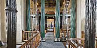
This magnificent example of 19th Century public works architecture preserves two 45-foot-high 70-ton steam engines which pumped the first clean water to the city of Hamilton over 140 years ago. One engine operates as a demonstration every day!The only surviving facility of its time in North America, the museum is a National Historic Site and a Civil and Power Engineering Landmark. These Canadian-made engines are the oldest surviving examples in the nation.
Thomas Keefer, one of Canada's most noted engineers, selected two independently-operating 70-ton Woolf Compound Rotative Beam Engines to pump Lake Ontario Water to a reservoir atop the Niagara Escarpment to be later carried though pipes to the growing city of Hamilton below. The engines were built by the Dundas Iron and Brass Foundry.
Location
Lat: 43° 15' 23.87" N
Long: 80° 47' 19.54" W
Elevation: 74 meters
Precision is: High. Pinpoints the exact spot.
Equipment
A Canon EOS 5D with a Canon 16-35mm L-series lens set at 16mm was used on a Manfrotto 303SPH head. The spherical panorama was stitched together with RealViz Stitcher V4. This panorama was shot with available light at 1/6 of a second @ f5.6 in RAW mode with an ISO of 800 on the Canon EOS 5D. I processed all of the images in the RAW conversion software Camera Raw 4.6 from Adobe.
 Tap or click the zoom icon in the bottom right corner of the picture to switch between in-page and fullscreen view