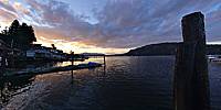
WWP Home arrow right This Event arrow right Indices: Alphabetical | Regional | Thumbnail | Map previousPrevious | Nextnext
event title
USA
portrait Bob Bright
Cowichan Bay Sunset
Cowichan Bay, Vancouver Island, British Columbia, Canada
mini manual

This should be a panorama image.

If you can read this, something went wrong.
We support these player technologies:

With ... you can view ...
Apple QuicktimeVR
(part of Quicktime)
all contributions
Adobe Flash Player 10.1 or newer most (not all, some contributions are QTVR-only due to historical reasons)
Javascript + HTML5 / WebGL many, but depends on photographer's choice of file upload (newer event = more likely to work) and your device's capabilities. You may experience slow playback, distorted images or unexpected browser quitting if there is only limited memory/GPU power available.
[?]
Copyright © 2010 Bob Bright, All Rights Reserved
VictoriaVR.ca
Previous panorama: Jeffry BrewerfullscreenA-Z Regions ThumbnlsShow in MapNext panorama: Wil Brugman

A tranquil contrast with the hustle and bustle of the Cowichan Bay waterfront during the busy summer tourist season.

Location Map Geographic Coordinates:
Latitude: 48° 44' 28.48" N
Longitude: 123° 37' 24.67" W
Precision is: High. Pinpoints the exact spot.

arrow Show at MultiMap.com [what is MultiMap?]
arrow Show at Google Maps [what is Google Maps?]
arrow Show in Google Earth* [what is Google Earth?]
* requires Google Earth
installed on your computer

Date/Time:
August 22, 2010, 8:00 pm PDT

Equipment:
Canon Rebel XT (350D), Tokina 10-17mm fisheye, Nodal Ninja 3, home-made pano pole


http://VictoriaVR.ca

text
WWP Home arrow right This Event arrow right Indices: Alphabetical | Regional | Thumbnail | Map previousPrevious | Nextnext