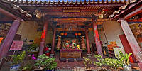

Dajia Wunchang Shrine — 大甲文昌祠
Dajia Township, Taichung County, Taiwan, China — 臺中縣大甲鎮
April 14, 2009, 06:49 UTC (14:49 TPE)

Loading panorama viewer ...
Configuring ...
© 2009 Walker Young, All Rights Reserved.
Caption
Wunchang Shrine was built in 1887. The construction funding was donated by wealthy local gentlemen of Dajia, and a private primary school was established at the shrine. Consequently, Wunchang Shrine became the first school of Dajia, and a place celebrated for culture and education.
On November 27, 1985, the Ministry of the Interior declared "Wunchang Shrine" a 3rd class National Historic Site.
Location
Lat: 24° 20' 52.21" N
Long: 120° 37' 22.02" E
Elevation: 60.11
Precision is: High. Pinpoints the exact spot.
Equipment
Canon EOS 5D + 15mm/f2.8 fisheye
 Tap or click the zoom icon in the bottom right corner of the picture to switch between in-page and fullscreen view