

Loading panorama viewer ...
Configuring ...
© 2009 Tom Pollak, All Rights Reserved.
Caption
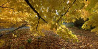
The Sugar Maple tree gives Vermont it's warm-colored end to the growing season.With the yellow, red and orange hews, the towns, hills and valleys come alive with bright color to contrast the blue sky, all seen mirrored in the lakes and streams. Here, seen up close, under the maple tree.
Location
Lat: 44° 8' 7.38" N
Long: 74° 5' 42.9" W
Elevation: 173 m
Precision is: Unknown / Undeclared.
Equipment
Nikon D2X, Sigma 8mm f4.5, Bogen Tripod, Nodal NinjaAdobe Lightroom, Photoshop CS, PTMac 3.0, CubicConverter
 Tap or click the zoom icon in the bottom right corner of the picture to switch between in-page and fullscreen view