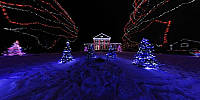

Alight at Night, Upper Canada Village
Morrisburg, Ontario, Canada
December 23, 2009, 18:30 (6:30 pm) ET

Loading panorama viewer ...
Configuring ...
© 2010 Robert Agnel, All Rights Reserved.
Caption
Alight at NightMore than 250,000 lights adorn the heritage buildings, trees and fences of Upper Canada Village creating a one-of-a-kind magical backdrop for its annual Alight at Night festival.
Location
Lat: 44° 56' 50.63" N
Long: 76° 4' 55.58" W
Elevation: 63 m
Precision is: Unknown / Undeclared.
Equipment
Nikon D90, Nikkor 10.5mm fisheye lens, 360 Precision panorama head, Manfrotto 055XDB tripod, Stitcher Unlimited, Pano2VR.
 Tap or click the zoom icon in the bottom right corner of the picture to switch between in-page and fullscreen view