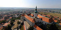

Aerial Panorama above Mikulov
Mikulov, Moravia, Czech Republic
September 28, 2009, 12:34 pm

Loading panorama viewer ...
Configuring ...
© 2009 Martin Hrdlička, All Rights Reserved.
Caption
Aerial panorama above the town of Mikulov, a well-known centre of Viticulture tradition in the southern part of the Czech Republic.
Equipment
zeppelin
 Tap or click the zoom icon in the bottom right corner of the picture to switch between in-page and fullscreen view