
Watching All the Cars Go By
Above San Francisco, California, USA
September 18, 2009, 17:55 PDT

Loading panorama viewer ...
Configuring ...
© 2009 Landis Bennett, All Rights Reserved.
Caption
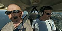
This has been a busy and exciting year for me. The panorama is actually one of the few that I've taken this year as I've been spending most of my time doing what you see me doing here: flying. The image may not be my best panorama in a long time, but it does a very good job representing 2009.This is a Traffic Watch flight. We fly over the highways and freeways of the SF Bay Area. The pilot handles the plane, the airspace, the weather. The reporter sits in the left seat, observes the traffic, and reports it to local radio stations. Some days it's more work than others - usually due to the weather. But many days we spend 2-3 hours at a time enjoying the view from above one of the most beautiful places on earth.
Special thanks to Derek for helping out with this panorama and for being an all around fun guy to work with.
360Geographics - Panoramas from all over North America of tourist destinations and places off the beaten path.
Location
Lat: 37° 48' 40.78" N
Long: 123° 28' 20.83" W
Elevation: 1,200 ft MSL
Precision is: Medium. Nearby, but not to the last decimal.
Equipment
Hardware: Nikon D200, Nikkor 10.5mm lens, Nodal Ninja, Cessna 172Software: PTGui/Mac, Photoshop CS3, Garage Band
 Tap or click the zoom icon in the bottom right corner of the picture to switch between in-page and fullscreen view