

Loading panorama viewer ...
Configuring ...
© 2009 Jürgen Schrader, All Rights Reserved.
Caption
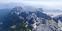
Flying in a so-called UL (Ultralight) airplane over the Bavarian Alps heading towards the Zugspitze, the highest peak in Germany.Looking down one can see the Schachenhaus, which is one of the famous retreats by ancient Bavarian King Ludwig II.
Location
Lat: 47° 25' 11" N
Long: 11° 6' 45" E
Precision is: Medium. Nearby, but not to the last decimal.
Equipment
The picture was taken with a Canon 5D and a Nikkor 10.5mm stuck out on a monopod.
 Tap or click the zoom icon in the bottom right corner of the picture to switch between in-page and fullscreen view