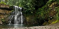
WWP Home arrow right This Event arrow right Indices: Alphabetical | Regional | Thumbnail | Map previousPrevious | Nextnext
event title
USA
portrait Jim Cole
Upper North Falls
Silver Falls State Park, Oregon, USA
mini manual

This should be a panorama image.

If you can read this, something went wrong.
We support these player technologies:

With ... you can view ...
Apple QuicktimeVR
(part of Quicktime)
all contributions
Adobe Flash Player 10.1 or newer most (not all, some contributions are QTVR-only due to historical reasons)
Javascript + HTML5 / WebGL many, but depends on photographer's choice of file upload (newer event = more likely to work) and your device's capabilities. You may experience slow playback, distorted images or unexpected browser quitting if there is only limited memory/GPU power available.
[?]
Copyright © 2009 Jim Cole, All Rights Reserved
Whole Reality
Previous panorama: Uri CoganfullscreenA-Z Regions ThumbnlsShow in MapNext panorama: Alain Collet

Silver Falls State Park is home to a series of beautiful waterfalls, most running year-round. Hiking trails link them, but some are also near roads and a lodge. Upper North Falls is one of the more modest, yet still quite pretty, and is an easy short walk from the road. During late summer the water flow is low enough to allow relatively close photography, and it is a popular location for its beauty and ease of access.

Location Map Geographic Coordinates:
Latitude: 44° 52' 59.88" N
Longitude: 122° 36' 54" W
Elevation: 1550 ft.
Precision is: High. Pinpoints the exact spot.

arrow Show at MultiMap.com [what is MultiMap?]
arrow Show at Google Maps [what is Google Maps?]
arrow Show in Google Earth* [what is Google Earth?]
* requires Google Earth
installed on your computer

Date/Time:
August 8, 2009, 19:35 UTC (12:35PM local time)

Equipment:
Nikon D300, Nikkor 10.5mm fisheye, Nodal Ninja 5, PTGui, Photoshop CS3, Pano2VR


http://www.oregonstateparks.org/park_211.php

http://wholereality.com

text
WWP Home arrow right This Event arrow right Indices: Alphabetical | Regional | Thumbnail | Map previousPrevious | Nextnext