
Los Hervideros (Boiling Waters)
Lanzarote, Islas Canarias, España
February 19, 2009, 14:51 UTC (15:51 local)

Loading panorama viewer ...
Configuring ...
© 2009 James Gentles, All Rights Reserved.
Caption
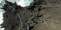
Los Hervideros (or "Boiling Waters") are a series of strange shaped rock formations where molten lava solidified as it met the ocean. As the name implies the sea bubbles and boils in the lava caves, chimneys and arches created by erosion, especially when there are heavy Atlantic swells.Looking inland you can see the post-volcanic landscape left after this part of the island was riven with huge volcanic eruptions in the 1730s, which lasted over 6 years. Whilst rendering the island almost uninhabitable at the time they have left a unique landscape here, and elsewhere a fertile soil.
See more Kite Aerial Photography at http://www.gentles.info/KAP
Location
Lat: 28° 57' 16.71" N
Long: 14° 50' 58.72" W
Elevation: Sea Level plus 50m
Precision is: High. Pinpoints the exact spot.
Equipment
Nikon 8400 with FC-E9 Lens. Homemade camera cradle/rig, triggered by a gentLED intervalometer. Suspended below a Sutton Flowform 16ft^2 kite.This technique produces two hemispheres, and a different workflow in PTGui from the classic ground pano technique. This results in lower resolution BUT impossible angles!
See the rig, how Kite Aerial Photography is achieved, and the workflow.
 Tap or click the zoom icon in the bottom right corner of the picture to switch between in-page and fullscreen view