

Loading panorama viewer ...
Configuring ...
© 2009 Henk Keijzer, All Rights Reserved.
Caption
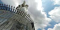
From Wikipedia:Our Lady of Lebanon (Arabic,سيدة لبنان), also known as "Saydet Libnan" or Notre Dame du Liban, is the patron saint of the Mediterranean country of Lebanon. In 1907, the French made, painted in white, bronze statue of the Virgin Mary, was erected on top of a hill, 650 meters above sea level, in the village of Harissa, 20 km north of Beirut in honor of Our Lady of Lebanon. It is made up of seven sections that were assembled on top of the stone base which has the shape of a trunk, with a bottom perimeter of 64m, an upper perimeter of 12m and with an overall height of 20m.The statue made with molten Bronze, painted white, gave the statue more splendor and clarity. The statue is 8.50m in height, 5.50m in perimeter and weights 15 tons. The location of the Shrine which overlooks the Bay of Jounieh, is considered one of the world’s most beautiful sceneries. The statute and the shrine were inaugurated in 1908, and since then it has become a major pilgrimage destination in Lebanon. The Lebanese Christians as well as the Druze and Muslims have a special devotion to the Blessed Virgin Mary. The Maronite Patriarch of Antioch named her the "Queen of Lebanon" in 1908 upon completion of the shrine.
Overlooking the bay of Jounieh, the shrine has become a major tourist attraction where tourists take the gondola lift, the Téléférique, from the city of Jounieh to Harissa.
Location
Lat: 33° 58' 54.5" N
Long: 35° 39' 6.23" E
Elevation: 650 meter
Precision is: High. Pinpoints the exact spot.
Equipment
Olympus E-30Peleng 8mm/f3.5
Handheld
Hugin
Smartblend
Photoshop
 Tap or click the zoom icon in the bottom right corner of the picture to switch between in-page and fullscreen view