

Loading panorama viewer ...
Configuring ...
© 2010 Douglas Cape, All Rights Reserved.
Caption
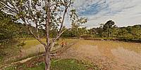
This Panorama is part of the Cultured Rainforest Project, due to go online in 2010.The Project features over 100 panoramas detailing archaeology and anthropology in the Kelabit Highlands around Pa'Dalih, Sarawak.
Here we are a few kilometres outside Pa'Dalih before Batu Patong, looking over a baa (rice field) and with an abandoned longhouse in sight.
Location
Lat: 3° 32' 40" N
Long: 115° 33' 12" E
Elevation: 993
Precision is: High. Pinpoints the exact spot.
Equipment
Nikon D700, Sigma 12-24mm, 360 Precision Adjuste.
 Tap or click the zoom icon in the bottom right corner of the picture to switch between in-page and fullscreen view