
Victorian Bushfire Aftermath
Chum Creek Forest, Victoria, Australia
March 30, 2009, 16:39 pm

Loading panorama viewer ...
Configuring ...
© 2009 Aaron Spence, All Rights Reserved.
Caption
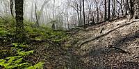
The devastating Victorian Bushfires of February 2009 led to the death of almost 200 people and the loss of over 2,000 homes. They were the worst bushfires in our recorded history.On the 22nd of May, 2008, Rodrick Bond, a Panedia photographer, shot a series of panoramas in Chum Creek Forest & the surrounding regions using our standard pano rig which includes a GPS plugged into the Nikon Body.
On the 30th of March, 2009, I spent the day traveling around sites Rodrick had shot in May of 2008. Most sites were unharmed by the bushfires, but the Chum Creek Forest had been severely burned.
Using the GPS data he had recorded I attempted to shoot the charred bush from the same positions Rodrick had, the year before. Time was not on my side as I flew back home that night, so I needed to work quickly, and somewhat approximately.
The panorama I've chosen as my "Best of" for 2009 is a combination of 2 shots, 1 before the fires, and 1 after. Both taken from the same position. There is a soft blend on the 2 seams that separate the images, where you'll see less than perfect registration. I estimate I was 1-2 metres from the exact position Rodrick had shot from.
To view more panoramas shot before the fires go here: http://maps.panedia.com/?pano=4788&mt=h&z=12
Location
Australia - New Zealand / Australia
Lat: 38° 37' 11.4" S
Long: 145° 28' 15.6" E
Elevation: 191m / 626ft
Precision is: High. Pinpoints the exact spot.
Equipment
This combination panorama was shot with 2 pano rigs.Before: Nikon D300 + 10.5mm, 360 Precision Absolute, Di-GPS, Manfotto legs.
After: Nikon D700 + 16mm, 360 Precision Adjuste, Manfrotto Legs.
 Tap or click the zoom icon in the bottom right corner of the picture to switch between in-page and fullscreen view