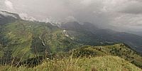

Peak of Mountain Gobbelikanda (next to Bambarakanda, Sri Lanka's highest waterfall)
Kalupahana, Badulla District, Sri Lanka
December 15, 2008, 08:48 UTC (14:18 local time)

Loading panorama viewer ...
Configuring ...
© 2008 Ruwan Janapriya Egoda Gamage, All Rights Reserved.
Caption
The peak of mountain Gobbelikanda is approximately 1,760M above sea level. It is located in the vicinity of Sri Lanka's Highest Waterfall; Bambarakanda Waterfall (241M high) and Wangedigala Rock.
Location
Lat: 6° 45' 36" N
Long: 80° 49' 4.8" E
Precision is: Medium. Nearby, but not to the last decimal.
Equipment
Canon 20D Camera Peleng 8mm fisheye Lens
Nodal Ninja 3 Panohead
Bogen Manfrotto 725B Tripod
 Tap or click the zoom icon in the bottom right corner of the picture to switch between in-page and fullscreen view