

Loading panorama viewer ...
Configuring ...
© 2008 Paul Stewart, All Rights Reserved.
Caption
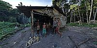
The farming technique known as "Chamkar" can be equated to slash and burn. It is a traditional method of clearing land for subsistence agriculture.In this case it took six men ten days to clear this plot in the middle of Prey Lang Forest.
No power saws, just axes to the largest trees and felled them so they took the smaller trees with them.
It is an unprotected forest region and home to many rare species of flora and fauna. It supports an estimated 700,000 people and is threatened by clear cutting from foreign and local interests.
See more panoramas from Prey Lang Forest here: http://mouthtosource.net/rivers/preylang/
See more here: http://www.mouthtosource.net/
 Tap or click the zoom icon in the bottom right corner of the picture to switch between in-page and fullscreen view