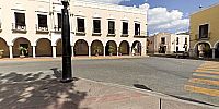

Southeast Corner of Parque Principal
Valladolid, Yucatan, Mexico
6 March, 2008, 15h45 -6 UTC Mexico Time

Loading panorama viewer ...
Configuring ...
© 2008 Pat Albright,
Some Rights Reserved.

Caption
Traveling 2.5 hours South West on Ctra Cancun - Valladoid (old Highway MEX 180) is a colonial town of Valladoid. On the southeast corner of the Main Plaza is the City Hall and Post Office. Valladoid is a friendly, clean and quiet township. The tall building in the background is San Servacio Church which is open for tourist visitors. Later that evening we returned to Cancun on the new faster Tollway MEX 180"D".Did I mention that: Temperatures were Air 90°F (32°C) and Beer 36.5°F (2.5°C)?
Location
Lat: 20° 41' 23.26" N
Long: 89° 13' 4.45" W
Elevation: 76 feet Mean Sea Level
Precision is: Medium. Nearby, but not to the last decimal.
Equipment
Canon 5d, Sigma 8mm f3.5, Mrotator RingTS8 head, Slik Monopod, 4 raw CR2 images, Adobe Raw Converter 4.5, Adobe Photoshop CS3, Easypano Panoweaver 5, PTGui Pro 8.02, Pano2VR 2.2b4
 Tap or click the zoom icon in the bottom right corner of the picture to switch between in-page and fullscreen view