

Loading panorama viewer ...
Configuring ...
© 2008 Norma Boylan, All Rights Reserved.
Caption
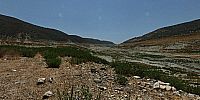
Kouris dam is the largest of a network of 107 dams in Cyprus. It lies at an altitude of 250m and collects the water delivered by the rivers Kouris, Limnatis and Kryos.On this day I was standing on slightly raised ground in the middle of the reservoir bottom.
The pano opens looking at the dam wall in the distance and the small amount of water left in there, estimated to be little more than a weeks worth for the rather large town of Limasoll and the surrounding areas.
The high water level, from early March 2004, can be seen quite clearly.
Turn 180 degrees around and if you zoom in you might see the "new" village of Alassa which overlooks the reservoir and Dam wall, to the left of which there are 4 high - dead - trees in a row. Behind the trees is the small old village church (built pre-1910) which was under water in early March 2004 when the water in the dam breached the wall for the first - and only time.
Location
Lat: 34° 44' 57.73" N
Long: 32° 58' 19.92" E
Elevation: 250 Metres
Precision is: Unknown / Undeclared.
Equipment
Taken with a Canon EOS 400D digital camera, with a Zenitar-M 16mm Fisheye f/2.8 lens mounted on a Panosaurus Pano head. Stitched using HugIn and rendered with Cubic Convertor.
 Tap or click the zoom icon in the bottom right corner of the picture to switch between in-page and fullscreen view