
Fresh Colors for Democracy
Munich, Bavaria, Germany
September 23, 2008, 15:35 UTC (17:35 local time)

Loading panorama viewer ...
Configuring ...
© 2008 Carl von Einem, All Rights Reserved.
Caption
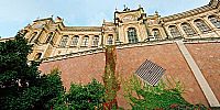
Colorful autumn leaves seem to reach out for the building... very much like several political parties who newly (or again) try to win seats here. At the same time the sky looks as if the ruling party had a dark sense of foreboding.The building is named Maximilianeum and today primarily serves as the seat of the Bavarian parliament (the "Landtag"). Only a couple of days after I took this shot the results of the 2008 Bavaria state election lead to a more colorful mixture of parties. More importantly this election ended a 46-year-long period of unbroken government of one single party.
A group of individuals without the status of an official political party (the Free Voters) even reached their aim to send canditates to the next Landtag. A remarkable success and an interesting new trend.
I actually shot this panorama for the last event "colors" in the hope of a major change in Bavaria's government. The location is very close to my very first WWP entry. Plans for 2009 include to participate in more World Wide Panorama events. A big Thank You to the team of organizers!
Have a great new year!
Location
Lat: 48° 8' 11.4" N
Long: 11° 35' 37.46" E
Elevation: 463 m (1519 ft)
Precision is: High. Pinpoints the exact spot.
Equipment
- Mamiya 7II (6x7 format rangefinder camera) with 43 mm lens (20 mm equivalent); customized panoramic head from Novoflex and Manfrotto parts on a Novoflex BasicBall tripod; 2 rows of 7 images (plus nadir and zenith) on Kodak Portra 160VC (220 film roll)
- Hasselblad Flextight 646 scanner
- stitching: hugin (0.7 svn3176), including autopano-sift, enblend and other great tools from the panotools community
- post-processing: Photoshop CS
- CubicConverter
 Tap or click the zoom icon in the bottom right corner of the picture to switch between in-page and fullscreen view