

Loading panorama viewer ...
Configuring ...
© 2008 Carl Rudlinton, All Rights Reserved.
Caption
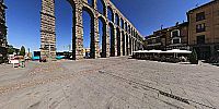
The Aqueduct of Segovia, typically the most recognized and famous symbol of Segovia, terminates at the entrance of the historic section. It was built at the end of 1st to early 2nd century BC by the Romans, during their occupation of the Iberian Peninsula, to bring water from the Río Frío (Cold River)(about 18 km away) to the city. It required an elevated section in its last 1 kilometer (0.6 mi) from the Sierra de Guadarrama to the walls of the old town. This elevated section, largely dominating the nearby scene, is supported by an engineering marvel of 166 arches and 120 pillars in two levels. It is made of 20,400 large, rough-hewn granite blocks, joined without mortar or clamps. Its maximum height of 28.1 m (100.53 ft) is found at the plaza of Azoguejo. A raised section of stonework in the center once had an inscription. Today only the holes for the bronze letters survive.
Equipment
4 Shot virtual image using 40D, 8mm Lens & Monopod.
 Tap or click the zoom icon in the bottom right corner of the picture to switch between in-page and fullscreen view