

Loading panorama viewer ...
Configuring ...
© 2008 Bernd Dohrmann, All Rights Reserved.
Caption
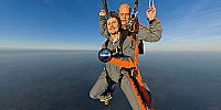
To make a full 360° panorama by skydiving was the hardest photojob I had in my lifetime.It was a truly adrenalin thrill !!! Now enjoy the view and the flight.
Some interesting links: Panorama in Fullscreen , Panorama "making of"
Location
Lat: 53° 59' 23.71" N
Long: 9° 34' 12.38" E
Elevation: 3000m above sea level
Precision is: Medium. Nearby, but not to the last decimal.
Equipment
Hardware:Canon400D - Sigma 8mm f/3.5 - cable release
homemade bracket - Monopod ... and a lot of crepe tape ...
Software:
ARC 4.3 - Photoshop CS2 - PTGui - Pano2QTVR
 Tap or click the zoom icon in the bottom right corner of the picture to switch between in-page and fullscreen view