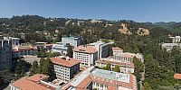

The Campanile at Berkeley
University of California, Berkeley, California, USA
June 16, 2007 3:48PM

Loading panorama viewer ...
Configuring ...
© 2007 Willy Kaemena, All Rights Reserved.
Caption
Sather Tower, known as the Campanile, was completed in 1914 and stands 307 feet (93.57m) tall. An elevator ride to the observation platform at the 200 foot (61m) level provides visitors with a spectacular view of the entire Bay Area and of the campus.Watch a short film directed by Paul Debevec made in the spring of 1997 that used image-based modeling and rendering techniques from his Ph.D. thesis to create photorealistic virtual cinematography of the UC Berkeley campus.
Location
Lat: 37° 52' 19.52" N
Long: 123° 16' 27.98" W
Elevation: 154m
Precision is: High. Pinpoints the exact spot.
Equipment
Nikon D200 with Nikor 8mm, hand held 12 photos. PS CS2, PTGUI PRO for Mac, CubicConverter, CubicConnector,
 Tap or click the zoom icon in the bottom right corner of the picture to switch between in-page and fullscreen view