

Loading panorama viewer ...
Configuring ...
© 2007 Steve Pendleton, All Rights Reserved.
Caption
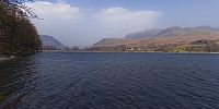
Why have I chosen this particular panorama?Well, for me, The Lake District in Cumbria is a part of the country that I love to visit and on this occasion we were blessed with almost perfect weather and as anyone who knows this area will confirm, that's pretty rare.
Buttermere itself is considered by many to be the most beautiful of all the lakes and is surrounded by majestic fells that provide some of the best walking that the UK has to offer.
See more of my work at: http://www.fullscreenpanoramas.co.uk
Location
Lat: 54° 31' 54.03" N
Long: 4° 17' 17.35" W
Elevation: 128 metres
Precision is: High. Pinpoints the exact spot.
Equipment
Shot in RAW format with a Canon EOS 20D and Sigma 8mm Fisheye, mounted on a Nodal Ninja NN3 Pano Head and Manfrotto 190 tripod. 4 portrait shots taken at 90 degrees plus zenith and a handheld nadir image. Stitched in PTGui on a PowerMac G5 and output to layered PSD. Cube faces created in CubicConverter, nadir patched in Photoshop and final movie output from CC.
 Tap or click the zoom icon in the bottom right corner of the picture to switch between in-page and fullscreen view