

Loading panorama viewer ...
Configuring ...
© 2007 Sachio Izumi, All Rights Reserved.
Caption
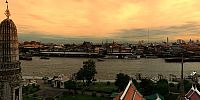
Located on the west bank of the Chao Phraya River, this temple can be reached either by Arun Amarin Road or by boat from Tha Tien Pier, near Wat Pho. It was restored during the brief Thonburi period to be the Royal Chapel of King Taksin. An important structure is a 79 meter-high pagoda or "Phra Phang" decorated with ceramic tiles and fragments of multicoloured porcelain. The name of this temple literary means "Temple of the Dawn" but the most beautiful view of it can be seen from the east side of the river at sunset.The text is quoted by Thailand Guidebook.com
Thailand Guidebook.com: http://www.thailandguidebook.com/index.html
WIKIPEDIA: http://en.wikipedia.org/wiki/Wat_Arun
Equipment
Canon-KissDN,Sigma8㎜,Kaidan,manfrotto,
 Tap or click the zoom icon in the bottom right corner of the picture to switch between in-page and fullscreen view