

Loading panorama viewer ...
Configuring ...
© 2007 Robert C. Fisher, All Rights Reserved.
Caption
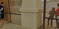
I was working on a TV show in Imperial Beach, California and my wife and I went out to explore the area. We drove around and hiked for a bit but in our travels we stumbled upon this park right at the US-Mexico border. There was a lot of activity on the Mexican side since this is right by the beach and the local bull ring. On the US side there weren't many people at all, 2 SUVs with border-patrol and a few other people including the students we spoke to. The US Government is in the process of adding another wall to the fence that is already there so now US citizens won't even be able to see the US side of the monument. This park was built in the '70s and used to be very nice, lots of grass and trees and no fence along the border inside the park. With budget cuts this bit of the park gets no attention now. The Mexican side sees a lot of visitors still. The area now reminds me of images from the Berlin Wall in Germany (but in reverse). The free side had lots of visitors and activity, the Communist side was walls, fences and guards.
What does this say about us?
Equipment
Hardware: Nikon D200 camera, Nikkor 10.5mm full frame fisheye lens, 360 Precision Absolute Panorama head, Bogen tripod and MAudio Microtrack audio recorderSoftware: PTGui 6, Photoshop CS, Cubic Converter, Amadeus Pro 1 audio editor.
 Tap or click the zoom icon in the bottom right corner of the picture to switch between in-page and fullscreen view