
Arkaden
Way Through Valley Towards Vals, Graubünden, Switzerland
Thursday, Nov. 1st 2007, noon

Loading panorama viewer ...
Configuring ...
© 2007 Joachim Vollmer, All Rights Reserved.
Caption
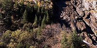
I shot this scene for a printed pano (that I have at home now); but also viewed interactively it shows very well two opposing sides of civilization: Creation and destruction. Nature and construction: Without the road and required construction work I surely had never seen this place (and even more beautiful ones later that day up the road) but at the same time the beautiful countryside that you can see across the river had to be sacrificed to an extent.
Location
Lat: 46° 40' 6" N
Long: 9° 10' 54" E
Precision is: Medium. Nearby, but not to the last decimal.
Equipment
Shot with a Fuji S3Pro, Nikkor 10,5 mm fisheye and a selfmade panohead in Raw Mode. Converted with Adobe Bridge (PS Raw Converter). Stiched with PTGui/PanoTools/Enblend, retouched with Photoshop, converted to QT with PanoCube.
Exposure 1/60 s and 1/8 s at f/8
 Tap or click the zoom icon in the bottom right corner of the picture to switch between in-page and fullscreen view