

Loading panorama viewer ...
Configuring ...
© 2007 James Gentles, All Rights Reserved.
Caption
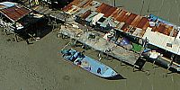
Penang Island, in the Straits of Malacca, is an island of Asian contrasts. In the south it is heavily industrialised, in the north are the remains of a colonial past with narrow streets, red pan-tile roofs and architecture from three centuries sharing the same space.Beneath the surface is also the contrast between the rich, working in the new industry, and the poor making their living in the traditional way.
Just off the new east coast highway fishermen tie up their boats to this pier they have made themselves. They rest under the corrugated iron roofs, waiting for dusk and fishing to start. Occasionally they look at the European who has come to "take pictures", and is prepaired to stay out in the hot afternoon sun, but mostly they wait.
Location
Lat: 5° 22' 6.7" N
Long: 100° 18' 53.8" E
Elevation: 0m (camera at ~25m)
Precision is: High. Pinpoints the exact spot.
Equipment
Nikon 8400 with FC-E9 Lens. Home-made camera cradle / rig, triggered by a gentLED intervalometer. Suspended below a mini-KAPilot kite approximately 16ft^2 area. This technique produces two hemispheres, and a different workflow in PTGui from the classic ground pano technique. This results in lower resolution BUT impossible angles!
See the rig at http://www.gentles.info/KAP/Rigs/index.htm?item=7 how Kite Aerial Photography is achieved at http://www.gentles.info/KAP/Overview/index.htm and the workflow at http://www.gentles.info/KAP/Gallery/Panotechnique/index.htm
 Tap or click the zoom icon in the bottom right corner of the picture to switch between in-page and fullscreen view