

Loading panorama viewer ...
Configuring ...
© 2007 Francis Fougere, All Rights Reserved.
Caption
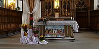
Église Saint-Hubert5310 ch. Chambly, Saint-Hubert, Quebec
This small church is one of the oldest on the south shore of Montreal. The exterior is built of stone and masonry and the interior is handcrafted wood. The architect was Victor Bourgeau and construction began in May of 1858. Blessed on January 9, 1859 by Monseigneur Ignace Bourget the Archbishop of Montreal, the church was completed on the 15th of October 1862. The first mass was celebrated on October 28th 1862. When visiting my mother and her parish I have often marvelled at the craftsmanship in this fine church and wonder if these woodworking skills have been lost over time.
Location
Lat: 45° 30' 17" N
Long: 74° 26' 16.56" W
Elevation: 89 Ft.
Precision is: High. Pinpoints the exact spot.
Equipment
A Canon EOS 5D with a Canon 16-35mm L series lens set at the 16mm setting was used on a Manfrotto 303SPH head. The cubic panorama was stitched together with RealViz Stitcher V4. This panorama was shot with available light at 1 second @ f 8 in Raw mode with an ISO of 100 on the Canon EOS 5D. I processed all the images in the RAW conversion software Capture One Pro V3.7 from Phase. This software allows me to set the white point balance, drop the contrast, adjust the colour saturation, and fine tune the exposures before I create pixels. This process allows for a better workflow and cleaner files then correcting in PhotoShop. The images are then stitched together in RealViz Stitcher and the QuickTime panoramas are then converted from the flat tiff images
 Tap or click the zoom icon in the bottom right corner of the picture to switch between in-page and fullscreen view