

Loading panorama viewer ...
Configuring ...
© 2007 Andy Savage, All Rights Reserved.
Caption
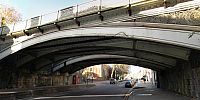
This is a view of Friar Gate Railway Bridge in the City of Derby, it was built in 1878 by Andrew Handyside and Co.
Back in 1877 when the Great Northern Railway wanted to put a railway route through Friar Gate, there was public outrage as this was a very affluent area with many fine Georgian buildings.
Because of this, the railway company was forced into having a bridge designed that was highly decorative, the likes of which had not been done before.
Andrew Handyside was a world famous Iron Founder who lived and worked in Derby. His work can still be seen all over the world today.
This bridge still stands today thanks to the great work done by The Friar Gate Bridge Action Group, who in 1973 managed to campain to stop the bridge from being demolished. They managed to get the bridge put on the Listed Buildings registry.
Despite this fact, today this bridge is in a very poor state and in need of some serious attention before its too late. For this reason I have created a petition for people to sign and show their support to demand that this bridge is restored.
Please show your support for local history by signing it.
Please sign the Friar Gate Bridge Restoration Petition here.
In addition to this 360 view you can take a look at several other 360s of this bridge from other angles as well as flash based versions :
Additional 360 views here.
To learn more about the bridge please see the dedicated Friar Gate Bridge feature here:
Friar Gate Bridge Feature.
More Details on Andrew Handyside and Co.
Did you know, The famous Flanagan and Allen song Underneath the Arches was written about this bridge. We should have a plaque erected under the bridge.
Hopefully in time the bridge will be restored.
Equipment
Nikon D70 fitted with Nikor 10.5 Lens on a Nodal Ninja head. Stitched with PtGui, converted to Cube in Pano2Qtvr, edited in Paint Shop Pro and finished in Pano2Qtvr.
 Tap or click the zoom icon in the bottom right corner of the picture to switch between in-page and fullscreen view