WWP Home arrow right This Event arrow right Indices: Alphabetical | Regional | Thumbnail | Map previousPrevious | Nextnext
event title
Europe
portrait Alain Collet
Bouillouses
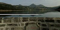
Bouillouses's Dam, Pyrénées, France
mini manual

This should be a panorama image.

If you can read this, something went wrong.
We support these player technologies:

With ... you can view ...
Apple QuicktimeVR
(part of Quicktime)
all contributions
Adobe Flash Player 10.1 or newer most (not all, some contributions are QTVR-only due to historical reasons)
Javascript + HTML5 / WebGL many, but depends on photographer's choice of file upload (newer event = more likely to work) and your device's capabilities. You may experience slow playback, distorted images or unexpected browser quitting if there is only limited memory/GPU power available.
[?]
Copyright © 2007 Alain Collet, All Rights Reserved
OROPHOTO
Previous panorama: Uri CoganfullscreenA-Z Regions ThumbnlsShow in MapNext panorama: Richard Crowest

This is a dam in one of the most beautiful places of Pyrénées, the lake is surrounded with summits like Pic Péric and Pic Carlit that are easy to climb and offer great views.

Location Map Geographic Coordinates:
Latitude: 42° 33' 41.58" N
Longitude: 1° 59' 18.98" E
Precision is: High. Pinpoints the exact spot.

arrow Show at MultiMap.com [what is MultiMap?]
arrow Show at Google Maps [what is Google Maps?]
arrow Show in Google Earth* [what is Google Earth?]
* requires Google Earth
installed on your computer

Date/Time:
August 25, 2007 - 06:52 UTC (08:52 local time)


http://www.alain-collet.com/Pyr/Ax.html

More photos and panos from this area of Pyrénées

WWP Home arrow right This Event arrow right Indices: Alphabetical | Regional | Thumbnail | Map previousPrevious | Nextnext