

Loading panorama viewer ...
Configuring ...
© 2006 Yiorgos Teo, All Rights Reserved.
Caption
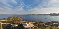
Aerial panorama of Lavrion, an industrial town on the eastern shores of Attica, Greece. Not far from Athens, the area was known in antiquity for its silver mines which furnished Athens with much of the basis of its power and wealth. It still maintains its industrial character and you can see the power plant as well as a chemical plant right next to it.This panorama was shot by lifting the camera with a kite.
Part of a series of aerial panoramas of different areas of Greece.
Location
Lat: 37° 44' 20.63" N
Long: 24° 4' 2.36" E
Elevation: 0
Precision is: High. Pinpoints the exact spot.
Equipment
Canon 350DPeleng 8mm
Rokkaku 8' kite
Wind: N 2.5 Beaufort
 Tap or click the zoom icon in the bottom right corner of the picture to switch between in-page and fullscreen view