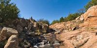

Dog Run Hollow Canyon
Wichita Mountains National Wildlife Refuge, Oklahoma, USA
October 17, 2006 • 12:30 CDT (17:30 UTC)

Loading panorama viewer ...
Configuring ...
© 2006 Victor Zaveduk,
Some Rights Reserved.

Caption
Although Chicago is our home and we love it dearly, my wife Barb and I also love to travel and explore tucked away corners of the US. This fall, we used our fall camping trip to explore the "middle" of the country, areas we'd only passed through or flown over in the past. Our trip took us to southwestern Oklahoma and we were delighted to find the region much more varied than we expected. We also found much warmer weather than expected! Although it would be snowing back home within days of this shot, we found ourselves hiking in t-shirts and shorts, enjoying lovely, sunny days surrounded by mountains and prairies, and marveling at elk, buffalo, and longhorn cattle.The view is in the middle of a small tributary to West Cache Creek, among the canyons at the lower end of Dog Run Hollow. A topographical map of the area can be seen by clicking here. After a very busy year for the both of us, this trip turned out to be the best three weeks of the year.
Location
Lat: 34° 42' 17.28" N
Long: 99° 42' 16.44" W
Elevation: 1450
Precision is: Unknown / Undeclared.
Equipment
This panorama was composed from a 10 images, taken with a Nikon D80 camera equipped with a Nikor 10.5mm wide-angle lens, mounted on a Nodal-Ninja SPH-1 spherical bracket atop a monopod/hiking pole. The images were stitched using PanoTools and PTGui (version 6), postprocessed with Photoshop CS2, and compiled into MOV format using Pano2QTVR.
 Tap or click the zoom icon in the bottom right corner of the picture to switch between in-page and fullscreen view