

Loading panorama viewer ...
Configuring ...
© 2006 John Riley, All Rights Reserved.
Caption
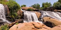
Falls Park on the Reedy River is considered to be the birthplace of Greenville, SC. Ten square miles of land along the Reedy River were purchased from three Cherokee chiefs by Richard Pearis in 1773. He established a trading post on the location and later operated grist and saw mills at the Upper Falls; the foundation of that mill are visible to the left of the falls in the panorama. Furman Institution (now Furman University) purchased the land in 1852, when its campus was relocated to Greenville. Furman relocated to a new campus outside the city in the late 1950's and the South Carolina Governor's School for the Arts now stands on its former location along the Reedy River, adjacent to the park.Three textile mills and a cotton warehouse operated along the river in the early part of the 20th century and the river became badly polluted. The current park was begun in 1967 by the Carolina Foothills Garden Club, with the help of the City of Greenville, Furman University and the Greenville Planning Commission. The park was developed by the city and the Garden Club over the next 40 years with the help of individual, corporate and government agencies.
The crowning achievment in the transformation of the park was the completion in 2004 of the stunning Liberty Bridge, which crosses the river just below the falls and may be seen in the panorama by panning around opposite the falls. This pedestrian bridge is 355 feet long and 12 feet wide, with a radius of curvature of 214 feet. The deck is supported by a single suspension cable strung from two 90 foot masts and is cantilevered towards the waterfall. The geometry of the bridge is unique.
Falls Park is the result of visionary leadership in the community and has transformed a polluted eyesore into a regional attraction. It offers a relaxing and beautiful retreat in the heart of an urban area.
Location
USA-Canada / USA-South Carolina
Lat: 34° 50' 41.5" N
Long: 83° 25' 3.29" W
Precision is: High. Pinpoints the exact spot.
Equipment
The images were captured using a Fuji S2 Pro digital SLR mounted on a 360Precision panohead. RAW images were developed using Adobe Photoshop CS3 and stitched using PTGui.
 Tap or click the zoom icon in the bottom right corner of the picture to switch between in-page and fullscreen view