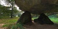

"Bronneger Dolmen"
Bronneger Drenthe, The Netherlands
oktober 22, 2006 - 15.30 local time

Loading panorama viewer ...
Configuring ...
© 2006 Gerard Kuster,
Some Rights Reserved.

Caption
In the north of the Netherlands, in the province Drenthe, within a radius of only 30 kilometers, 53 megalithic monuments are scattered over a beautiful landscape. Granite skeletons of 5500 years old burial chambers. Where did these 20 ton boulders come from, how were they piled up and by whom and why..? What is the mystery behind these relics from the past..? If you want to know more about these mysterious stonegraves go to the site of Hans Meijer, Assen the Netherlands: http://www.hunebedden.nl/frntpage.htm
Equipment
Canon EOS 10D, Sigma 8mm, Manfrotto Tripod with selfmade Panoramahead, Photoshop CS + PTGui.
 Tap or click the zoom icon in the bottom right corner of the picture to switch between in-page and fullscreen view