

Loading panorama viewer ...
Configuring ...
© 2006 Francois Cochin, All Rights Reserved.
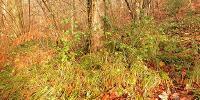
Caption
Taken at the time of a pedestrian excursion, one Sunday morning, when the fog rose... Close to the EDF electric dam of Rabodanges, one of finest of France.Pris lors d'une randonnée pédestre, un dimanche matin, au lever du brouillard... Près du barrage électrique EDF de Rabodanges, un des plus fins de France.
www.pixlounge.com
Equipment
Taken with a Nikon Coolpix 5000 @ 28 mm, homemade panohead and gitzo tripod.
 Tap or click the zoom icon in the bottom right corner of the picture to switch between in-page and fullscreen view