
View from the Basler Münster
Basel, Switzerland
September 6, 2006 (about 3 pm local time)

Loading panorama viewer ...
Configuring ...
© 2006 Claudia Betschart,
Some Rights Reserved.

Caption
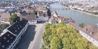
The town of Basel is located in the northwestern corner of Switzerland on the river Rhine, in the so called “Dreiländereck” (three countries corner) where Switzerland, Germany and France meet. Already in prehistoric times the area was settled by Celtics. Latest around the middle of the first century BC a fortified settlement was constructed on the Münster Hügel (Minster hill), soon followed by a Roman military base. The oldest parts of the cathedral date back to the 8th century. This first building was rebuilt, altered, and enlarged several times through the centuries, in particular after damage by fire in 1058 and 1258, as well as after the devastating earthquake of 1356. Today’s Minster therefore has elements from Romanesque to Gothic style. The former five towers of the cathedral were destroyed by the earthquake and only two of them, the George’s tower and the Martin’s tower have been rebuilt.
Even today the cathedral is under constant construction because the local sandstone is suffering from the air pollution. It therefore was a very rare opportunity to admire the building without any scaffolding during just a few weeks this summer. The panorama was taken from the highest gallery of the George’s tower (therefore not visible in the picture). George’s tower (north tower) is the older of the two towers and was finished in 1429. Visible is Martin’s tower (south tower) that was finished in 1500 and this also marked the completion of today’s Münster.
The buildings around the Münster square are mainly from the 18th century. Looking across the river Rhine you will notice a high, blue building: the “Messeturm” (trade fair tower). It was completed in October 2003 and with 105 m currently is the highest building in Switzerland, housing offices, a hotel, restaurant and bar. Looking in the same direction you can see the Minster ferry crossing the Rhine. It was featured at the last WWP event on transportation.
Here you find more information on the city of Basel http://www.basel.ch/en/basel/home and on the Münster (in German only) http://www.baslermuenster.ch/
Equipment
Hardware: Nikon FM3, Sigma 8mm fisheye lens, slide film scanned on Polaroid Sprint Scan 35Plus
Software: PTGui, Adobe Photoshop, Pano2QTVR
 Tap or click the zoom icon in the bottom right corner of the picture to switch between in-page and fullscreen view